🎉 Up to 70% Off Selected ItemsShop Sale

Maine - Guide Book and Maps
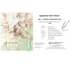
The Maine edition covers 282 miles from Katahdin in Baxter State Park to the New Hampshire state line in one planning guide and seven water- and tear-resistant maps. The pocket-sized planning guide contains background information, points of interest, and road-access directions. Each map is focused on the Appalachian Trail and overlaps with the neighboring maps. The surrounding area and additional side trails are also included. An easy-to-use elevation profile shows the ups and downs and the distance to the next campsite or shelter, side trails, and water sources.
$8.98
Original: $29.95
-70%Maine - Guide Book and Maps—
$29.95
$8.98More Images


Maine - Guide Book and Maps
The Maine edition covers 282 miles from Katahdin in Baxter State Park to the New Hampshire state line in one planning guide and seven water- and tear-resistant maps. The pocket-sized planning guide contains background information, points of interest, and road-access directions. Each map is focused on the Appalachian Trail and overlaps with the neighboring maps. The surrounding area and additional side trails are also included. An easy-to-use elevation profile shows the ups and downs and the distance to the next campsite or shelter, side trails, and water sources.
Product Information
Product Information
Shipping & Returns
Shipping & Returns
Description
The Maine edition covers 282 miles from Katahdin in Baxter State Park to the New Hampshire state line in one planning guide and seven water- and tear-resistant maps. The pocket-sized planning guide contains background information, points of interest, and road-access directions. Each map is focused on the Appalachian Trail and overlaps with the neighboring maps. The surrounding area and additional side trails are also included. An easy-to-use elevation profile shows the ups and downs and the distance to the next campsite or shelter, side trails, and water sources.